FLOOD GLOSSARY
The following is provided as a curated summary of terms taken from the referenced standards that appear in the article footing.
SEE ALSO OUR GENERAL GLOSSARY OF TERMS
NATIONAL FLOOD INSURANCE PROGRAM (NFIP)
The Federal program, create by an act of Congress in 1968, that makes flood insurance available in communities that enact satisfactory floodplain management regulations.
FLOOD INSURANCE RATE MAP (FIRM)
The official map of a community prepared by FEMA that shows the BFE, along with the special flood hazard area and the risk premium zones for flood insurance purposes. Once it has been accepted, the community is part of the regular phase of the NFIP.
FIRM MAP LINK
https://msc.fema.gov/portal/search
NATIONAL GEODETIC VERTICAL DATUM OF 1929 (NGVD)
Elevation datum plane previously used by FEMA for the determination of flood elevations.
NORTH AMERICAN VERTICAL DATUM OF 1988 PLANE (NAVD)
Elevation datum currently used by FEMA for the determination of flood elevations.
FEMA FLOOD ZONES
FEMA Flood Insurance Rate Map (coastal)
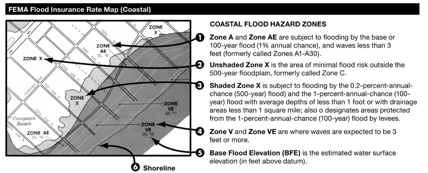
ASCE – Most Restrictive Zone Applies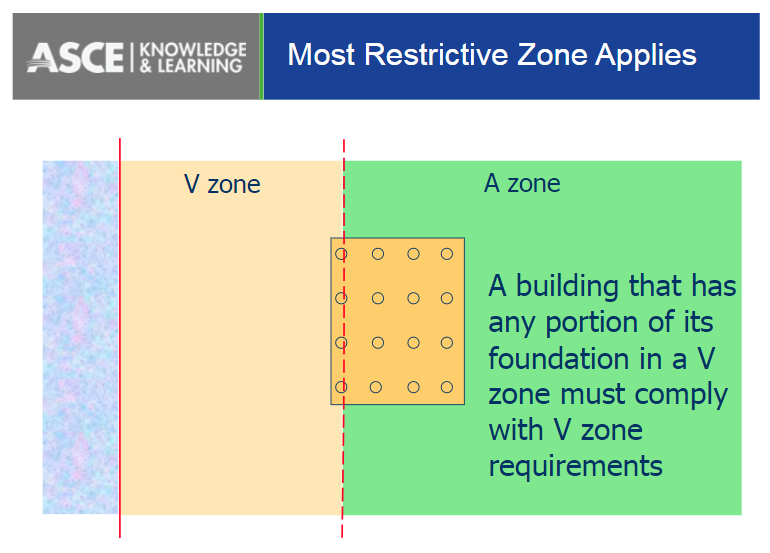
Flood hazard areas identified on the Flood Insurance Rate Map are identified as a Special Flood Hazard Area (SFHA). SFHA are defined as the area that will be inundated by the flood event having a 1-percent chance of being equaled or exceeded in any given year. The 1-percent annual chance flood is also referred to as the base flood or 100-year flood. SFHAs are labeled as Zone A, Zone AO, Zone AH, Zones A1-A30, Zone AE, Zone A99, Zone AR, Zone AR/AE, Zone AR/AO, Zone AR/A1-A30, Zone AR/A, Zone V, Zone VE, and Zones V1-V30. Moderate flood hazard areas, labeled Zone B or Zone X (shaded) are also shown on the FIRM, and are the areas between the limits of the base flood and the 0.2-percent-annual-chance (or 500-year) flood. The areas of minimal flood hazard, which are the areas outside the SFHA and higher than the elevation of the 0.2-percent-annual-chance flood, are labeled Zone C or Zone X (unshaded).
100-YEAR FLOOD
The flood that has a one-percent chance of being equaled or exceeded in any given year. It is also known as the Base Flood.
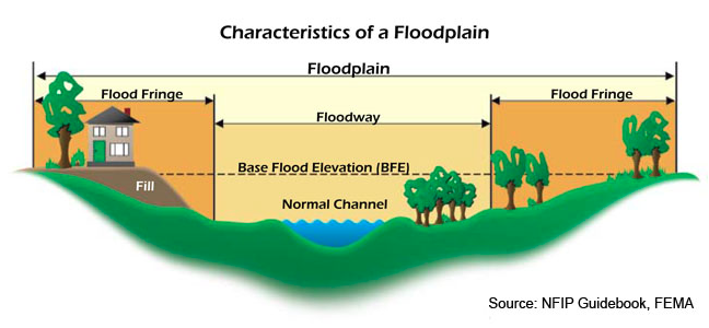
SPECIAL FLOOD HAZARD AREAS (SFHA)
Portion of the floodplain subject to inundation by the base flood, designated Zone A, AE, A1 – A30, AH, AO, AR, V, VE, or V1 – V30 on a FIRM.
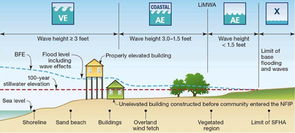
V ZONES (COASTAL HIGH HAZARD)
Area within a special flood hazard area extending from offshore to the inland limit of a primary frontal dune along an open coast and any other area that is subject to high velocity wave action from storms or seismic sources. This area is designated on FIRMs as velocity zones V, VO, VE, or V1-30.
COASTAL A ZONES (CAZ)
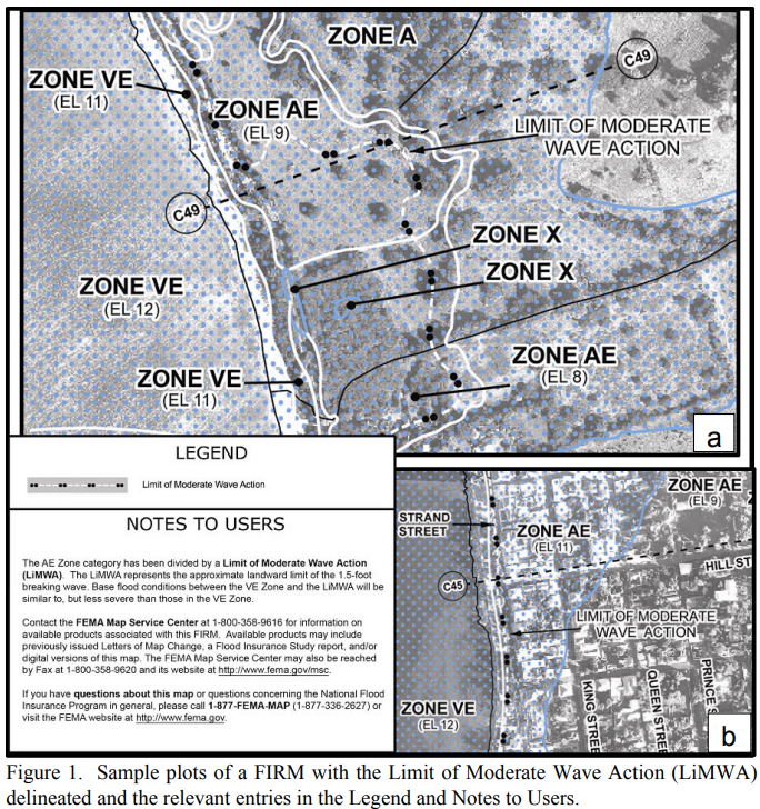
Area within a special flood hazard area, landward of a V Zone or landward of an open coast without mapped V Zones. In a Coastal A Zone, the principal source of flooding must be astronomical tides, storm surges, seiches, or tsunamis, not riverine flooding. During the base flood conditions, the potential for breaking wave heights shall be greater than or equal to 1.5 ft. The inland limit of the Coastal A Zone is (1) the Limit of Moderate Wave Action if delineated on a FIRM, or (2) designated by the authority having jurisdiction.
LIMIT OF MODERATE WAVE ACTION (LiMWA)
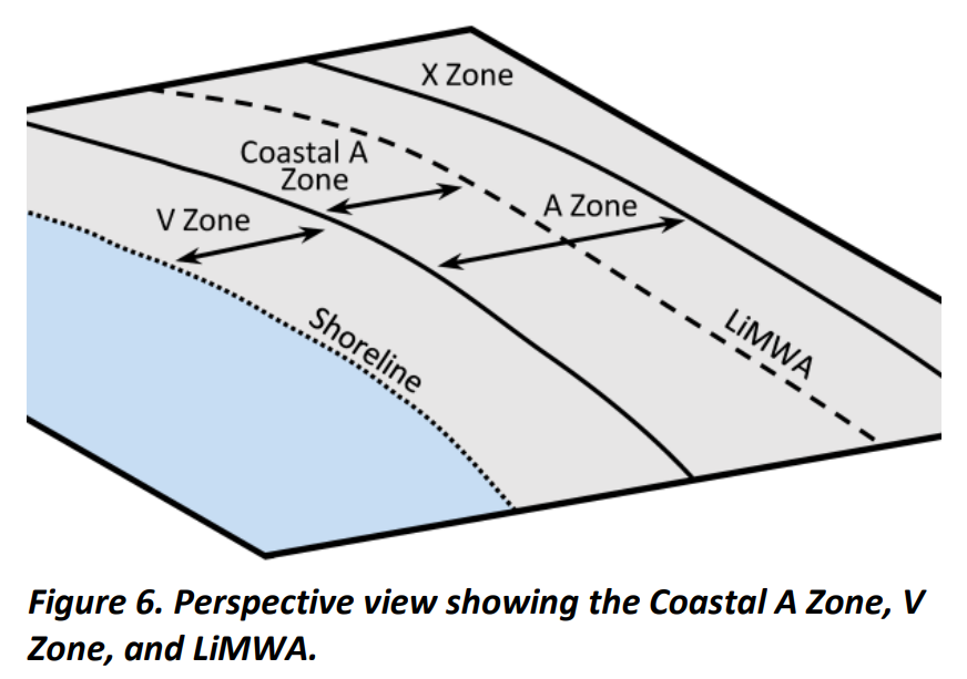
Line shown on FIRMs to indicate the inland limit of the 1.5-ft breaking wave height during the base flood.
A ZONES
Areas subject to inundation by the 1-percent-annual-chance flood event generally determined using approximate methodologies. Because detailed hydraulic analyses have not been performed, no Base Flood Elevations (BFEs) or flood depths are shown. Mandatory flood insurance purchase requirements and floodplain management standards apply.
X OR C ZONE
The areas of minimal flood hazard, which are the areas outside the SFHA and higher than the elevation of the 0.2-percent-annual-chance flood, are labeled Zone C or Zone X (unshaded).
BASE FLOOD ELEVATION (BFE)
Elevation of the 100-year flood. The BFE is determined by statistical analysis for each local area and is designated on the FIRMs. This elevation is the basis of the insurance and floodplain management requirements of the NFIP.
DESIGN FLOOD ELEVATION (DFE)
The elevation of the highest flood (generally the BFE including freeboard) that a retrofitting method is designed to protect against. Also referred to as Flood Protection Elevation.
FREEBOARD (FB)
Additional amount of height incorporated into the DFE to account for uncertainties in the determination of flood elevations.
FINISHED FLOOR (FF)
Finished floor elevation above a referenced datum typically sea level.
DESIGN WATER VELOCITY
Speed at which water moves during a flood. Velocities usually vary across the floodplain. They are usually greatest near the channel and lowest near the edges of the floodplain.
HYDROSTATIC LOADS
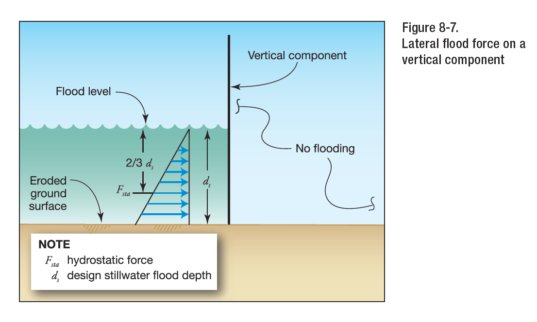
Hydrostatic loads are those caused by water either above or below the ground surface, free or
confined, which is either stagnant or moves at velocities less than 5 ft/s (1.52 m/s). These loads are equal to the product of the water pressure multiplied by the surface area on which the pressure acts. Hydrostatic pressure at any point is equal in all directions and always acts perpendicular to the surface on which it is applied. Hydrostatic loads can be subdivided into vertical downward loads, lateral loads, and vertical upward loads (uplift or buoyancy). Hydrostatic loads acting on inclined, rounded, or irregular surfaces may be resolved into vertical downward or upward loads and lateral loads based on the geometry of the surfaces and the distribution of hydrostatic pressure.
HYDRODYNAMIC LOADS
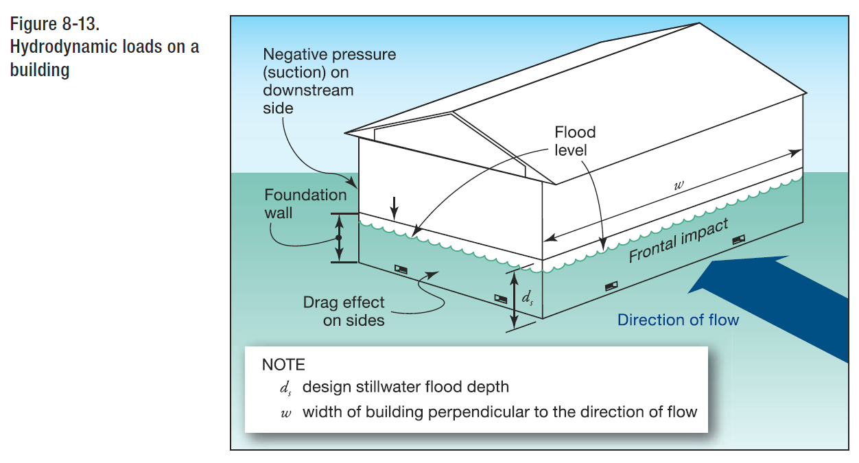
Where water velocities do not exceed 10 ft/s (3.05 m/s), dynamic effects of moving water shall be permitted to be converted into equivalent hydrostatic loads by increasing the DFE for design purposes by an equivalent surcharge depth, dh, on the headwater side and above the ground level only. Hydrodynamic loads are those loads induced by the flow of water moving at moderate to high velocity above the ground level. They are usually lateral loads caused by the impact of the moving mass of water and the drag forces as the water flows around the obstruction.
SURCHARGE DEPTH
When dynamic effects are converted to equivalent hydrostatic loads, the equivalent surcharge depth shall be added to the DFE design depth and the resultant hydrostatic pressures applied to, and uniformly distributed across, the vertical projected area of the building or structure that is perpendicular to the flow. Surfaces parallel to the flow or surfaces wetted by the tail water shall be subject to the hydrostatic pressures for depths to the DFE only.
BREAKING WAVE PRESSURE
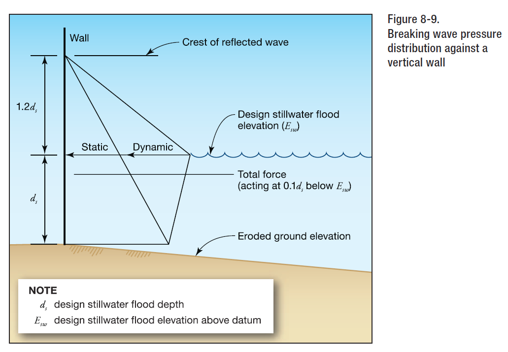
Maximum combined dynamic and static wave pressures, also referred to as shock pressures in lb/ft^2 (kN/m^2).
BREAKING WAVE FORCE
Net breaking wave force per unit length of structure, also referred to as shock, impulse, or wave impact force in lb/ft (kN/m), acting near the still water elevation.
BREAKING WAVE HEIGHT
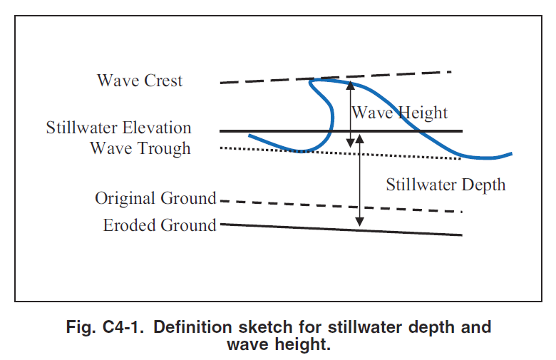
Vertical distance between wave crest and wave trough.
STILLWATER DEPTH
Elevation that the surface of the water would assume in the absence of waves referenced to a datum.
DEBRIS IMPACT FORCE
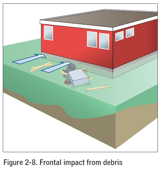
Debris Impact Load Per FEMA P-55
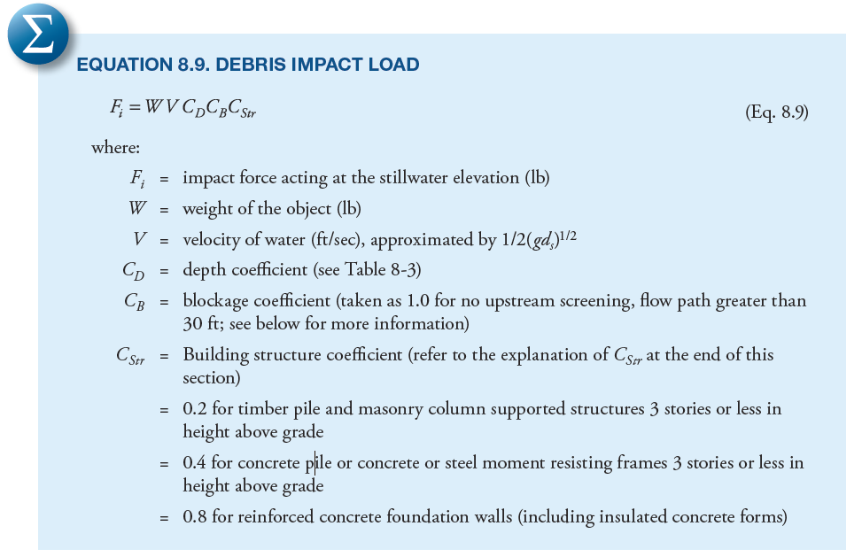
Debris impact loads are imposed on a building by objects carried by moving water. The magnitude of these loads is very difficult to predict, but some reasonable allowance must be made for them. The loads are influenced by where the building is located in the potential debris stream, specifically if it is:
- Immediately adjacent to or downstream from another building
- Downstream from large floatable objects (e.g., exposed or minimally covered storage tanks)
- Among closely spaced buildings
DEBRIS CHARACTERISTICS
The size, shape, and weight of waterborne debris may vary according to region. For example, the coasts of Washington, Oregon, and other areas may be subject to very large debris in the form of whole trees and logs along the shoreline. The southeastern coast of the United States may be more subject to debris impact from dune crossovers and destroyed buildings than other areas. In the absence of information about the nature of potential debris, a weight of 1,000 pounds is recommended as the value of W. Objects with this weight could include portions of damaged buildings, utility poles, portions of previously embedded piles, and empty storage tanks.
DEPTH COEFFICIENT (CD)
Per FEMA P-55
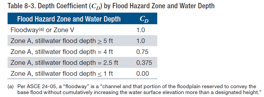
The depth coefficient (CD) accounts for reduced debris velocity as water depth decreases. For buildings in Zone A with stillwater flood depths greater than 5 feet or for buildings in Zone V, the depth coefficient = 1.0.
UPSTREAM SCREENING/BLOCKAGE COEFFICIENT (CB)
Per FEMA P-55
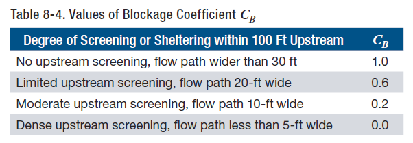
The blockage coefficient (CB) is used to account for the reduction in debris velocity expected to occur because of the screening provided by trees and other structures upstream from the structure or building on which the impact load is being calculated.
BUILDING STRUCTURE COEFFICIENT (CSTR)
Stiff or rigid buildings and structures with natural periods similar to the impact duration will see an amplification of the impact load. More flexible buildings and structures with natural periods greater than approximately four times the impact duration will see a reduction of the impact load. Likewise, stiff or rigid components will see an amplification of the impact load; more flexible components will see a reduction of the impact load. Calculating the natural period can be carried out using established methods that take building mass, stiffness, and configuration into account. Coefficient values for Cstr, (0.2, 0.4, and 0.8) were generated by selecting input values recommended in ASCE 7-10, Chapter C5, with appropriate assumptions made to model typical coastal residential structures.
Article provided by Zachary A. Rubin, P.E.
Engineering Express is glad to discuss your question or need in this field.
Feel free to Contact Us or call us at the numbers listed below.
RELATED ARTICLES:
Also see: FLOOD RESISTANT DESIGN & FLOODPROOFING OF BUILDINGS
REFERENCES & SOURCES:
- FEMA 3-93: Non-Residential Floodproofing for Buildings Located in Special Flood Hazard Areas in Accordance with National Flood Insurance Program
- FEMA P-55: Coastal Construction Manual
- FEMA 102: Floodproofing for Non-Residential Structures
- FEMA 259: Engineering Principles and Practices of Retrofitting Floodprone Residential Structures
- FEMA FL-RA1: Dry Floodproofing Operational Considerations
- gov
- ASCE 24-14: Flood Resistant Design
- ASCE 7-10: Minimum Design Loads for Buildings and Other Structures
Last Update: February 19, 2022